Our history
History of Saint Edward State Park
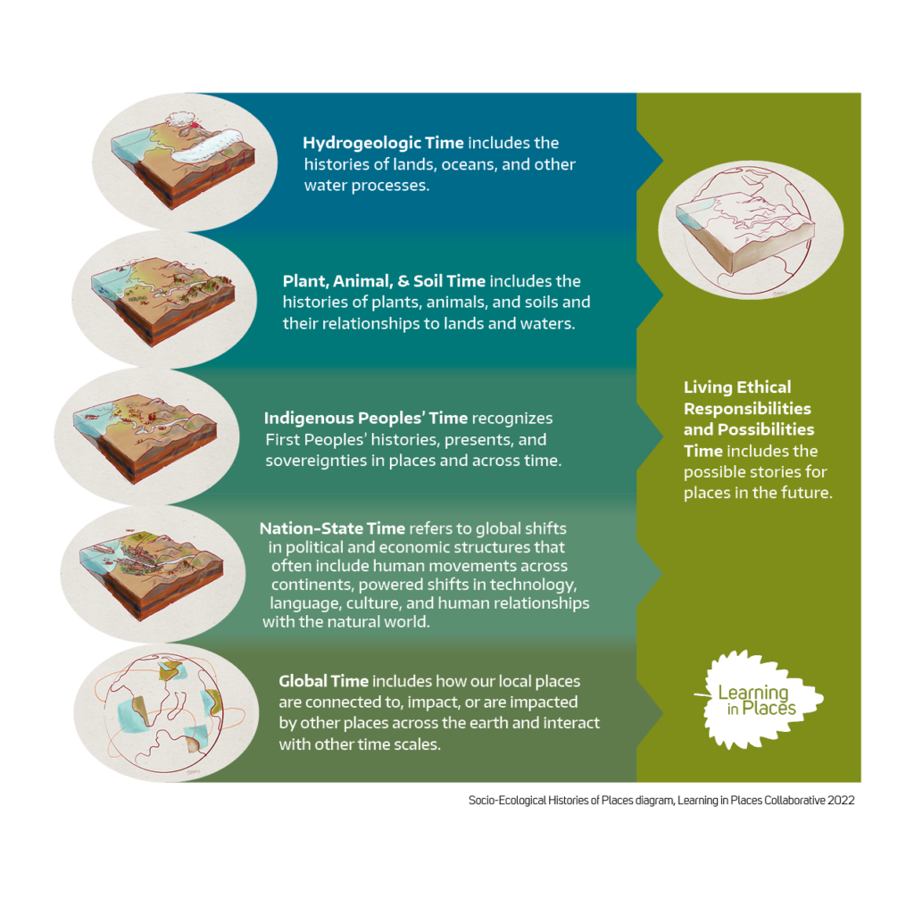
The following narrative traces the emergence of the Collaborative for Socio-Ecological Engagement (CoSEE) at the Environmental Education and Research Center (EERC), Saint Edward State Park using the Socio-Ecological Histories and Futures of Places Framework.
This framework invites learners to think across six interconnected timescales, from deep geological time to imagined futures, in order to understand how places came to be, and what they might become. The framework was developed by Dr. Megan Bang and Dr. Carrie Tzou, Principal Investigators of the Learning in Places Collaborative, and others on the Learning in Places team as a tool for supporting learner sense-making within and across time and place.
The ground beneath Saint Edward State Park carries the memory of ice. During the Vashon Stade of the Fraser Glaciation, roughly 19,000 to 16,000 years ago, a massive lobe of the Cordilleran Ice Sheet advanced south from British Columbia through what is now the Puget Lowland. At its peak, the glacier was over 4,000 feet thick in the northern lowlands — taller than any building on Earth — and extended as far south as what is now Olympia before beginning its rapid northward retreat.
As the Puget Lobe scoured and retreated, it carved out the deep north-south oriented trough that became Lake Washington, depositing hundreds of feet of Lawton Clay, Esperance Sand, and Vashon Till. Meltwater flowing beneath the ice cut the valleys, ravines, and spring-fed seeps we know today. The gently sloping bluffs of Saint Edward State Park — layered in glacial sediment and cut by ravines are a direct landform legacy of this glacial work. When the ice finally melted back, freshwater proglacial lakes pooled in the lowlands before draining north to the sea, eventually forming the stable lacustrine shoreline that defines this place. The bedrock of CoSEE’s work both literally and figuratively was laid down in the age of glaciers.
The north/south glacial advancement and retreat shaped the north/south orientation of Puget Sound and other landscape features in this region. However, water movement tends to run east to west into the Lake Washington, Puget Sound, and other area watersheds. Learn more using The Burke Museum’s Waterlines interactive and downloadable map.
As the glaciers melted and soils stabilized, life moved in. Over thousands of years, the northeast shore of Lake Washington transitioned from bare glacial outwash to the dense, layered temperate rainforest that visitors encounter in Saint Edward State Park today. Coast Douglas-fir, western red cedar, western hemlock, and bigleaf maple rose to form a multi-storied canopy above carpets of sword fern, Oregon grape, and trillium. Ravens, salmon, deer, muskrats, and many others species including countless invertebrates wove themselves into the complex socio-ecological webs of the place.
The ravines at Saint Edward are fed by springs that percolate through the glacial till, a hydrological signature of the ice age, and carry cool, clean water year-round toward the lake’s longest undeveloped shoreline. This mosaic of forest, wetland, ravine, and lakeshore sustains biological diversity that now anchors CoSEE’s place-based research and education programs. The forest that students and community members explore today is second-growth, the original old-growth was logged in the late 19th and early 20th centuries, but it is recovering, and its ecological complexity remains a living classroom for the interdisciplinary work CoSEE carries out.
Long before the seminary, the park, or the university, this shoreline was home to local Indigenous communities who are still here today. The Sammamish people (Lushootseed: sc’ababsh), a Lushootseed-speaking Southern Coast Salish people, have inhabited and continue to inhabit the shores of Lake Washington and the Sammamish River since the retreat of glaciers. Other Indigenous communities including the Duwamish and Snoqualmie nations also hold deep relationships with these lands and waters, fishing for salmon, harvesting camas and cedar, and maintaining sophisticated ecological knowledge across the broader watershed.
This area has never been separate from humans. This Land has always been a managed, storied, and deeply inhabited landscape. Indigenous sovereignty over these lands was never willingly ceded. The Point Elliott Treaty of 1855 dispossessed the Coast Salish peoples of the vast majority of their territory under conditions of extreme political and cultural pressure, and federal policy through the late 19th and early 20th centuries worked deliberately to dismantle tribal governance, culture, and land tenure. The Duwamish Tribe, whose territory encompasses metropolitan Seattle, remains without federal recognition to this day. Understanding CoSEE’s place means reckoning honestly with this history, and recognizing that Indigenous nations were, and remain, the original stewards of this land and its ecological knowledge systems.
Two defining acts of industrial-era decision-making transformed the physical and social geography of this place. In 1916, the completion of the Lake Washington Ship Canal, including the Montlake Cut connecting Lake Washington to Lake Union, and the Hiram Chittenden Locks at Ballard, which lowered Lake Washington by approximately nine feet. The engineering goal was to create a freshwater commercial harbor and boost economic development across King County. But the ecological and cultural consequences were severe: the Black River, the lake’s ancient southern outlet and a vital salmon corridor, disappeared almost overnight, devastating the salmon runs and the Indigenous communities that depended on them. A new shoreline was exposed all along the lake, including the bluffs and beaches that are now on the northeastern edge of Saint Edward State Park. The Lake Washington watershed lost 90% of its wetland habitat with the drop in water levels.
In 1917, Bishop Edward O’Dea purchased land at what was then called Deer Park, on the newly exposed shore of Lake Washington, donating it to the Roman Catholic Archdiocese of Seattle to establish a seminary. The Saint Edward Seminary building was designed by architect John Graham Sr. in the Romanesque Revival style and completed in 1931, serving as the Archdiocese’s main preparatory school for diocesan priests for 46 years. The seminary’s expansive grounds, managed by the Church for decades, would incidentally preserve 326 acres of forest from post-war suburban development — setting the stage for what would become a state park and ultimately the home of the EERC.
CoSEE exists precisely because the past matters to the future. The multilayered and multistoried histories of this place- glacial, ecological, Indigenous, colonial, institutional — does not simply recede. It accumulates, and it demands a response. The vision animating CoSEE is that the EERC at Saint Edward State Park can become a site where scientists, educators, students, families, and communities come together not just to study the land, but to co-author better relationships with it.
Creation of Environmental Education and Research Center (EERC)
2017
In 2017, Washington State Parks signed a lease with Daniels Real Estate company to renovate the old seminary building for use as a lodge or hotel. Through community backing and input the lease also included over 2,000 square feet of space for an environmental education research center (EERC) to be created in the gym annex building.
2018–2019
Through 2018 and 2019, there was a continuation of EERC Community-based planning taking place. The partnership between UW Bothell and Washington State Parks was signed along with funding from the Washington State Legislature. This process was led by EERC Planning Committee and EERC Community Advisory Board in which three public forums were held to discuss planning.
2020–2021
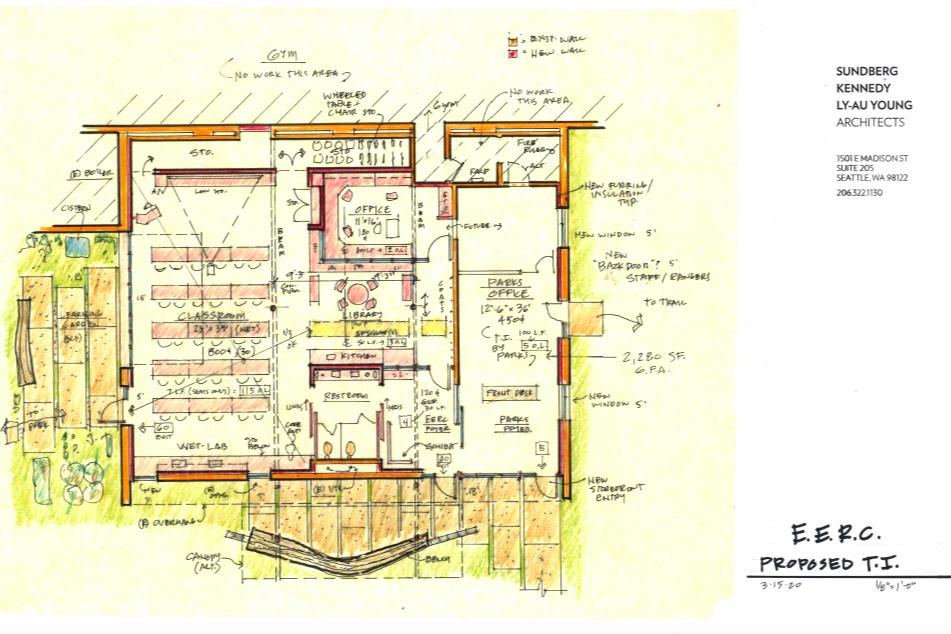
In between 2020 and 2021, the EERC allocated $750,000 from Washington State Legislature for facility design and renovation. The collaborative design work for the EERC was lead by Sundberg Kennedy Ly-Au Young (SKL) Architects. The design included:
- 2,200 square feet interior space with a classroom, office, and reading room space. As well as sinks and counters included for wet lab activities.
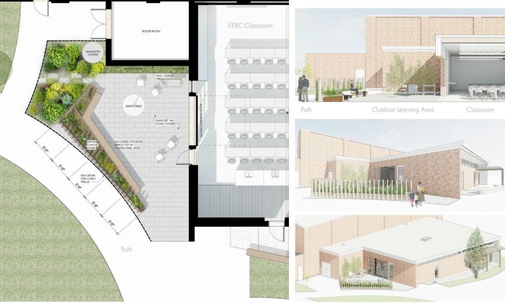
- Outdoor learning area that includes garden and seating.
- Sustainability design features leading to Core Green® Building Designation pending funding.
UW Bothell also committed support for 3.5 years to develop EERC infrastructure and programming. Renovations began in March 2021. Lastly, the EERC website, newsletter, and social media were established during this time.
2021–2022
Through 2021 and 2022, the EERC building finishes renovations. All spaces have been completed including the classroom, office space and Outdoor Learning Area (OLA).
2022–2023
Finally, in 2022 through 2023, UW Bothell equips the EERC with furniture, technology, and supplies. As well as the Interagency Agreement between UW, Bothell and Washington State Parks is completed and signed.